


Courtesy Pixabay
The weather is expected to go downhill starting Sunday morning with the biggest effects expected Sunday night into Monday across the entire Four States Area.
Here is the graphic and information from the National Weather Service in Shreveport:
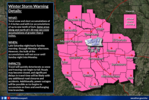
Winter Storm Warning
URGENT - WINTER WEATHER MESSAGE
National Weather Service Shreveport LA
225 AM CST Sat Feb 13 2021

...Winter Weather threat expected to ramp up early Sunday...

.A significant winter storm is expected to impact the entire Four
State region with a mix of snow, sleet, and freezing rain Sunday
night into Monday. However, before the worst of the storm arrives
on Monday, there is good potential for a burst of mainly sleet
and freezing rain across the region starting Sunday morning. As
such, the previously existing Winter Storm Watch has now been
upgraded to a Winter Storm Warning.

ARZ050-051-059>061-070>073-LAZ001>006-010>014-017>022-OKZ077-
TXZ096-097-108>112-124>126-136>138-149>153-165>167-131630-
/O.UPG.KSHV.WS.A.0002.210214T0600Z-210216T0000Z/
/O.NEW.KSHV.WS.W.0002.210214T0600Z-210216T0000Z/
Sevier-Howard-Little River-Hempstead-Nevada-Miller-Lafayette-
Columbia-Union-Caddo-Bossier-Webster-Claiborne-Lincoln-De Soto-
Red River-Bienville-Jackson-Ouachita-Sabine-Natchitoches-Winn-
Grant-Caldwell-La Salle-McCurtain-Bowie-Franklin-Titus-Camp-
Morris-Cass-Wood-Upshur-Marion-Smith-Gregg-Harrison-Cherokee-Rusk-
Panola-Nacogdoches-Shelby-Angelina-San Augustine-
Including the cities of De Queen, Nashville, Mineral Springs,
Dierks, Ashdown, Hope, Prescott, Texarkana, Stamps, Lewisville,
Bradley, Magnolia, El Dorado, Shreveport, Bossier City, Minden,
Springhill, Homer, Haynesville, Ruston, Farmerville, Bernice,
Mansfield, Stonewall, Logansport, Coushatta, Martin, Arcadia,
Ringgold, Gibsland, Jonesboro, Monroe, Many, Zwolle,
Pleasant Hill, Natchitoches, Winnfield, Colfax, Montgomery,
Dry Prong, Clarks, Grayson, Columbia, Jena, Midway, Olla, Idabel,
Broken Bow, Clarksville, Bogata, Mount Vernon, Mount Pleasant,
Pittsburg, Daingerfield, Lone Star, Naples, Omaha, Atlanta,
Linden, Hughes Springs, Queen City, Mineola, Winnsboro, Quitman,
Hawkins, Gilmer, Big Sandy, Jefferson, Tyler, Longview, Marshall,
Jacksonville, Rusk, Henderson, Carthage, Nacogdoches, Center,
Lufkin, San Augustine, Hemphill, and Pineland
225 AM CST Sat Feb 13 2021

...WINTER STORM WARNING IN EFFECT FROM MIDNIGHT TONIGHT TO 6 PM
CST MONDAY...


  WHAT...Heavy mixed precipitation expected. Total snow
  accumulations of 2 to 4 inches and ice accumulations of around
  one tenth of an inch. Some areas along and north of I-30 may see
  snow accumulations of greater than 6 inches. Heaviest snowfall
  rates will likely occur on Monday with the passing of the main
  system.

* WHERE...Area-wide across the Four-States region

* WHEN...From midnight tonight to 6 PM CST Monday.

* IMPACTS...Travel will quickly deteriorate as snow and freezing
  rain begin to fall. Roads may become closed, and significant
  delays in travel time will be likely with any additional road
  closures and accidents. Additionally, power outages will be
  possible as ice begins to accumulate on lines and overhanging
  tree branches.

PRECAUTIONARY/PREPAREDNESS ACTIONS...

If you must travel, keep an extra flashlight, food, and water in
your vehicle in case of an emergency.

The latest road conditions for the state you are calling from can
be obtained by calling 5 1 1.